By: Natalie Dunn, Senior Ecologist/Restoration Ecologist and Holly Stemberger, Environmental Planner
Did you know? A watershed is an area drained by a river(s) and its tributaries. The Great Lakes watershed includes the lands surrounding the Great Lakes in Canada and the United States, extending along the St. Lawrence Seaway and Gulf of Saint Lawrence, up to the Atlantic Ocean. When we look at the individual tributaries, which drain into rivers and eventually into the Great Lakes, we scope the study area into a subwatershed.
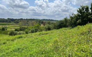
Think about every time it rains – where does it go? It flows across our communities, down streets and into storm drains or across fields, through forests and wetlands. Some of it is evaporated, some infiltrates into the soil, and some keeps flowing until it finds its way into tributaries – this is our subwatershed! From there on, rainwater travels downstream, flowing into rivers and ultimately into the Great Lakes – and that’s a watershed! Keep reading to learn about the value of subswatershed planning to ensure the long-term success of the entire watershed.
Why subwatershed planning?
As we navigate the complexities associated with growing communities – from building new houses and schools, to planning out water and wastewater services and road infrastructure – watershed and subwatershed planning are key components in land use planning. Watershed planning is an approach that considers upstream, downstream, and cumulative effects of land use changes on a scale beyond an individual community. It takes a big picture approach by assessing land use changes throughout the entire watershed.
Imagine rainwater flowing across a community – what happens when it crosses a farm field where fertilizers and pesticides are used? What happens when it flows down roads that are heavily salted in the winters before going into storm drains? All those pollutants are likely to get flushed along with the rainwater into our forests, wetlands, and ultimately our watercourses. And what happens if there’s a particularly large rainfall event, and there are no forests or wetlands to help absorb or slow down the flow of water into our tributaries and rivers? That’s when we start to experience hazards like erosion and flooding that can cause harm to people and property.
Subwatershed planning is intended to support land use and infrastructure design, promote informed decision-making, and lead to greater efficiency and effectiveness of the land use planning process. Addressing water resources and natural heritage resources at the same time other land use decisions are being made is an effort to protect quality and quantity at a local scale, while considering watershed level impact.
What does a subwatershed study involve?
As part of a comprehensive and sustainable land development process, many jurisdictions across North America require a subwatershed study as a starting point for new communities and settlement areas. These studies are completed to:
- Identify the natural heritage and hydrological features within a subwatershed (i.e. woodlands, wetlands, watercourses, and habitat for species at risk, amongst others);
- Assess potential impacts associated with future land use changes;
- Recommend strategies to avoid cumulative impacts on adjacent or downstream natural heritage and water resource systems;
- Identify measures to protect, restore, and/or enhance the natural heritage and water resource system while considering resiliency and longevity; and,
- Inform efficient and sustainable land use and infrastructure planning.
In the Province of Ontario, a subwatershed study is generally required to support any new Secondary Plan applications under the Planning Act. In some situations, these studies may be led by a municipality, developers, or collaboratively between municipalities and landowner groups.
Detailed studies are needed to understand ground and surface water conditions, how they interact with the environment, and how they can be protected and managed to make sure communities continue to:
- Have access to clean drinking water;
- Manage stormwater flow;
- Protect against flooding;
- Preserve ecological function; and,
- Address community resilience to climate change (stay tuned to this blog series for more on how climate change and subwatershed studies go hand in hand!).
The subwatershed study process usually takes at least one year to collect the appropriate level of baseline field data to identify existing conditions, assess potential impacts, and establish preferred land use scenarios. Time is also needed to determine appropriate management strategies such as low-impact development measures, identify suitable implementation of non-intensive recreation uses, and provide recommendations for naturalization plantings and restoration.
Indigenous engagement is another important element of a subwatershed study. There are many opportunities to collaborate throughout this study process such as knowledge sharing for a holistic understanding of past and present land use and existing conditions. Other initiatives may involve or be led by Indigenous communities, such as restoration design and implementation, conservation partnerships to implement ecological best management practices, monitoring efforts, and stewardship.
Value of a Subwatershed Study
A subwatershed study has tremendous value as a framework to ensure the long-term health of a watershed. Landscape level planning can be more sustainable and economical by:
- Studying the natural environment to understand existing conditions and what is needed to maintain quantity and improve quality;
- Protecting natural systems through an impact assessment and environmental policy recommendations; and
- Restoring, enhancing, and monitoring a contiguous and robust natural heritage system.
It might seem daunting to bring everything together, but these studies are important for projects that aim to protect people, property, and the natural heritage and water systems that connect our communities and our Great Lakes. Contact Natalie Dunn or Holly Stemberger to discuss subwatershed studies further.


